John McCurdy House
John McCurdy House
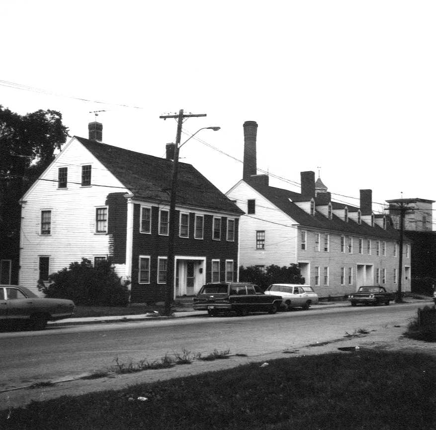
The John McCurdy House stood on the north side of Elm Street (now Old Elm Street) at Billerica Mills, between the John Mixer House and The Canal Block, on a narrow lot that ran back from the road to the towing path of the Middlesex Canal. It was built in 1847 by John McCurdy, an Irish immigrant, and stood until 1978.
The land was part of the old Osgood mill farm on the west bank of the Concord River, which passed from the estate of Christopher Osgood through Nicholas Sprake, William Kidder and John Carleton to Thomas Richardson. In 1794 Richardson sold "about forty acres" with the mills to the Proprietors of the Middlesex Canal. The canal laid out house lots along the road below its locks on a plan by Samuel Whiting in 1816, and in 1826 it sold lots 14, 15 and 16, twelve rods on the road, to John Mixer, whose house stood on them.
On December 15, 1845 Mixer sold John McCurdy of Billerica, victualler, the easterly four rods of this land for $225, a strip running about seven and a half rods from "the road leading from Israel Colsons to the Canal Mills" back to the towing path, bounded on the east by the canal's land. McCurdy gave a small mortgage to Charles P. Talbot and Thomas Talbot in April 1846, and on September 16, 1847 he mortgaged the lot to Daniel Wilson for $524, describing it as the land "on which I am now erecting a dwelling house". The same mortgage puts his east line "two feet Easterly from the west end of the Canal Block". The house was a Greek Revival dwelling that the 1974 survey called "an elegant extension of 'the Block' next door".
McCurdy, who called himself a manufacturer when he mortgaged the house to Mary Ann Frame of Lowell in December 1847, sold it to her outright on November 24, 1848 for $1,062.63, on condition that she pay off Daniel Wilson's mortgage. He kept living there: the 1850 census lists John McCurdy, 37, a laborer born in Ireland, with his wife Margaret, their children James and Mary J., and a crowd of Irish boarders, most of them laborers, among them a John Frame. A daughter, Mary Isabella, had been born to John and Margaret McCurdy in Billerica in February 1846. The 1853 map of Billerica still shows "J. McCurdy" at the house.
Mary Ann Frame married Andrew Mason of Lowell, and on April 26, 1855 the Masons sold the house lot, "one quarter of an acre ... with the buildings thereon", to Charles P. Talbot and Thomas Talbot for $1,400, the Talbots taking over the Wilson mortgage, which Wilson had assigned to them on May 2. The Talbots had bought the canal's land around it in 1851 and were turning the old canal mills into their woolen mill, and the house became housing for mill workers. The 1875 map shows it as property of C. P. Talbot and Co., and in 1884 the Talbot heirs conveyed their village land to the new corporation, The Talbot Mills.
When the company divided its village into house lots on the Monahan plan of 1936, the McCurdy house became Lot 70, 6,877 square feet on Elm Street. The Talbot Mills passed it to Talbot Mills, Inc. in 1944, and after the 1956 sale and merger of that company it went to Fabricon, Inc. in 1965. Fabricon sold Lots 70 and 71 (the McCurdy house and the Canal Block) to private owners in 1966, and the house, then numbered 9-11 Elm Street, was taken back by the Arlington Five Cents Savings Bank in a foreclosure in 1969 and changed hands privately several times in the 1970s. It was demolished in 1978, and in 1979 the empty lot was sold for $3,000 to CRT Development, which joined it to the old mill property. The site has since passed with the mill to Cambridge Tool and Manufacturing (1997) and L&P Aluminum Holdings (2008), and is now part of the mill parking lot at 1 Old Elm Street.
References
- MACRIS BIL.90
- Billerica assessor, 1 Old Elm St (parcel 9-94-0): the former Talbot mill property, which includes Lot 70 of Plan 60-28, the McCurdy house site
Title References
| Date | Type | Grantor | Grantee | Summary | Recorded |
|---|---|---|---|---|---|
| 1740 | Administration and Division | Estate of Capt. Christopher Osgood of Billerica, intestate | His widow Elizabeth Osgood (thirds) and his eldest son Christopher Osgood, millwright, administrators | 1740: Osgood mill farm, the land under the later canal village | Probate #16264 |
Administration granted October 26, 1739 to the widow Elizabeth and the eldest son Christopher. The committee's inventory of the real estate, April 17, 1740, values "one Gritt mill and mill pond with the River or Stream Called Concord River with the Dam & Sluces" at 800 pounds, a saw mill, half the iron works, a fulling mill, the dwelling house and barn, and "the Hom Sted Containing by Estimation forty one acres Bounded Southerly one Common land and westerly one the Road to Brod meadow and notherly by the way and mill yard to the River", in all 1,865 pounds. The widow's thirds were set off by metes and bounds, including a third of the grist, saw and fulling mills; the committee found that dividing the other two thirds "will discommode or spoile the whole", and they went to the eldest son Christopher. These are the two thirds of the farm and of "Osgoods Mills" sold in the 1749 to 1759 deeds. The land had come to Capt. Osgood by the town's grant of October 4, 1708 of the falls of Concord River for a mill.
Title passed to:
|
|||||
| 1748 | Will | Christopher Osgood of Billerica, miller | His executors William Stickney and Thomas Kidder, to sell; widow Sarah Osgood | 1748: will of Christopher Osgood, miller, the mill farm to be sold | Probate #16268 |
Will dated August 25, 1748. He leaves his personal estate to his wife Sarah and directs "that all my Real Estate be Sold by my Executors unto the best advantage", the proceeds to be divided among his children as the law directs in intestate estates, his wife having a third, and "that the timber at the mill be sawed" toward his debts. Executors William Stickney and Thomas Kidder of Billerica; witnesses Zachariah Shed, Nathaniel Davidson and Joseph Ruggles, the clothier to whom Osgood had sold land and water for a fulling mill in 1747.
Title from:
Title passed to:
|
|||||
| June 1, 1752 | Executors' Deed | William Stickney, yeoman, and Thomas Kidder, gentleman, of Billerica, executors of Christopher Osgood (Sarah Osgood, widow, releasing dower) | Nicholas Sprake of Billerica, clothier | 1749: Osgood executors sell the mill farm to Nicholas Sprake | 50/578 (South) |
Billerica town book 5, pages 249-252. Dated January 25, 1748/9 under the power of sale in the will. For 1,500 pounds in bills of credit, "about forty acres of Land ... on the west side of Concord River ... Easterly on said River westerly on a high way it being about two Thirds of the land which was granted by the Town of Billerica unto Capt. Christopher Osgood", "two thirds of the Mills commonly known by the name of Osgoods mills" and two thirds of the dam and stream "together with the Buildings thereon", as set off by a committee and accepted by the Judge of Probate. Conditions: whatever the town's vote of October 4, 1708 "granting said Land and Stream to Christopher Osgood the Father of the Testator" required, "a proper Passage for Fish", and the agreement with Joseph Ruggles. Acknowledged 1750, recorded June 1, 1752.
Title from:
Title passed to:
|
|||||
| January 13, 1757 | Deed | Nicholas Sprake of Billerica, miller (Judith Sprake releasing dower) | William Kidder of Billerica, gentleman | 1757: Sprake to William Kidder | 53/541 (South) |
Billerica town book 5, pages 373-376. Dated January 10, 1757. For 706 pounds 13 shillings 4 pence, the same "about forty acres of Land ... on the west side of Concord River", two thirds of "the Mills commonly known by the name of Osgoods Mills" and two thirds of the dam and stream "together with the Buildings thereon standing", on the conditions of the 1708 town vote, the fish passage and the Ruggles agreement, "And all the Real Estate that the said Christopher Osgood died seised and possessed of (excepting two thirds of a Pew and old stable and about twelve acres of Land it lies in a swamp called Captn Danforth's valued at two Pounds)".
Title from:
Title passed to:
|
|||||
| June 11, 1759 | Deed | William Kidder of Billerica, gentleman (Sarah Kidder releasing dower) | John Carleton of Boxford, Essex County, miller | 1759: Kidder to John Carleton | 56/413 (South) |
Billerica town book 5, pages 463-465. Dated March 9, 1759. For 800 pounds, "about forty Acres of Land ... on the west side of Concord River ... Easterly on said River Westerly on a high way it being about two Thirds of the Land which was granted by the Town of Billerica unto Captn Christopher Osgood", "Two Thirds of the Mills commonly known by the Name of Osgoods Mills" and two thirds of the dam and stream with the buildings, on the same conditions, with all the real estate Christopher Osgood died seised of except a pew, an old stable and twelve acres in Capt. Danforth's swamp. The mills were afterwards called Carleton's Mills.
Title from:
Title passed to:
|
|||||
| 1782 | Will and Division | Estate of John Carleton of Billerica, yeoman (Hannah Carleton, widow, executrix) | His widow Hannah (thirds) and children Nathan, John, Moses and Solomon Carleton, Elizabeth Todd, Hannah Laws and Lydia Mears | 1782: John Carleton estate divided | Probate #3943 |
The committee appointed by Judge Oliver Prescott appraised "the Homsted being by estimation Sixty Acres with a Dwelling House & barn a Grist mill & Saw-mill a shop also thereon standing Westerly by the Road or way Leading from the Fordway throu Concord River to Broad Meadow so called and on all other parts by said River" at 1,175 pounds, with meadow, woodland and a share of a Sabbath-day house, and set off to the widow Hannah her thirds, including the east end of the dwelling house and "one full third part of the [mills] ... for her natural life". The heirs gave Hannah Carleton, executrix, a discharge for their shares of the two thirds on December 21, 1786 (accepted March 12, 1787).
Title from:
Title passed to:
|
|||||
| March 31, 1794 | Deed | Solomon, Moses and Nathan Carleton, Jesse Manning, Thomas Todd, Thomas Laws and Thomas Mears, heirs of John Carleton, with their wives | Thomas Richardson of Billerica, gentleman | 1783: Carleton heirs to Thomas Richardson | 115/271 (South) |
Billerica town book 9, pages 87-91. Dated April 17, 1783, recorded March 31, 1794. For 818 pounds "lawful Silver money", "about forty Acres of Land ... on the West side of Concord River ... Easterly on said River, Westerly on the highway it being about two thirds of the land which was granted by the Town of Billerica unto Capt. Christopher Osgood", two thirds "of the Mills commonly known by the name of Osgoods or Carletons Mills" and two thirds of the dam and stream with the buildings, "as the same was set off by the Committee for the Widows Thirds", "meaning to convey two thirds of the Homested and Mills and Buildings thereon standing and the Shop is wholley conveyed". Richardson takes on two thirds of the 1708 town conditions, the Ruggles agreement and the repair of "the Bridge or Road" below the dam. Richardson later bought the widow's dower interest (S.115/274 and others) and in 1794 sold the whole as Richardson's Mills to the Middlesex Canal.
Title from:
Title passed to:
|
|||||
| March 31, 1794 | Quitclaim | Solomon Carlton of Fitchburg, yeoman, heir of John Carlton | Thomas Richardson of Billerica, gentleman | 1783: Solomon Carlton releases the widow's thirds to Richardson | 115/274 (South) |
Billerica town book 9, pages 91-92. Dated September 1, 1783. For 36 pounds 5 shillings, Solomon Carlton quitclaims his share in "that part of the real Estate of my Honoured Father John Carlton late of said Billerica Yeoman deceased, which was set off to my Honoured Mother Hannah Carlton as her Thirds or Dower", the reversion of the widow's third of the mills and homestead. Richardson bought the other heirs' shares of the dower in the same way (index: S.98/75, 1786, from Moses Carleton; S.105/315, 1789, from Nathan Carleton), and took a lease of the Carlton Mills from the widow (S.115/256), so that by 1794 he held the whole of what he sold to the canal as Richardson's Mills.
Title from:
|
|||||
| April 21, 1794 | Deed | Thomas Richardson of Billerica, gentleman (Judith Richardson releasing dower) | Ebenezer Hall of Medford and Samuel Jaques of Wilmington, a committee for the Proprietors of the Middlesex Canal | 1794: Richardson sells the mill farm to the Middlesex Canal | 115/259 (South) |
For 1350 pounds, "about forty acres of Land" bounded easterly by Concord River, westerly by the highway and northerly and southerly by the road; the reversion of half the dower of the widow Hannah Carlton, conveyed to him by Solomon, Moses and Nathan Carlton; five sixths of a small piece at the northeast end of the mill dam, bounded easterly "by Timothy Sprague's Ditch that conveys Water to the Fulling mill"; "together with all the Buildings ... including the Mills Mill priviledges ... commonly known by the name of Richardson's Mills being the same which was formerly granted by the Town of Billerica to Christopher Osgood together with the Mill Dam and Stream", on the conditions of the town's vote of October 4, 1708, a passage for fish, and his 1791 agreement with Timothy Sprague. Dated March 25, 1794; recorded April 21, 1794. Billerica town book 9, pages 81-82. The Canal Mills land from which the proprietors sold their small house lots.
Title from:
Title passed to:
Related:
|
|||||
| March 20, 1826 | Deed | Benjamin Guild of Boston, President of the Board of Directors of the Proprietors of the Middlesex Canal | John Mixer of Billerica | 1826: Canal sells John Mixer lots 14-16, the house lots below the locks | 265/208 (South) |
Under the proprietors' vote of March 13, 1826, for $600: a lot bounded easterly on land of Nathan Mears 10 rods, southerly on Mears 12 rods, westerly on Canal land 10 rods and northerly "on the road leading from O. Farmers house to the Canal Bridge at the Mills" 12 rods, three quarters of an acre (lots 1, 2 and 3 on Samuel Whiting's plan of May 1816); and "one other lot ... on the northerly side of the road leading from O. Farmers house to the Mills and directly on the opposite side of the road to the lot above conveyed", southerly on the road 12 rods, westerly on Canal land to "the towing path of said Canal", along the towing path 12 rods, easterly by Canal land about 7 1/2 rods to the road, "laid down as three lots marked number fourteen, fifteen and sixteen" on Whiting's plan of May 16, 1816. Dated March 15, 1826; recorded March 20, 1826. Billerica town book 12, pages 459-461. Lots 14-16 are the house lot.
Title from:
Title passed to:
|
|||||
| April 10, 1846 | Deed | John Mixer of Billerica, yeoman (Nancy Mixer releasing dower) | John McCurdy of Billerica, victualler | 1845: Mixer sells John McCurdy the easterly four rods | 480/546 (South) |
Billerica town book 18, pages 136-137 (Southern Registry Book 480, Page 546, per the grantee index). Dated December 15, 1845. For $225, the easterly four rods of Mixer's homestead lot on the north side of the road, "Beginning at the south easterly corner of the premises at land of the Proprietors of the Middlesex Canal and at the road leading from Israel Colsons to the Canal Mills", north on the Proprietors' land about 7 1/2 rods to the towing path, west on the towing path four rods, south to the road and east on the road four rods, "with the buildings thereon". This is the lot of the John McCurdy House; its east line is bare canal land, the future or present site of the Canal Block, which is not named.
Title from:
Title passed to:
Related:
|
|||||
| April 10, 1846 | Mortgage | John McCurdy of Billerica (Margaret McCurdy releasing dower) | Charles P. Talbot of Lowell and Thomas Talbot of Billerica | 1846: McCurdy mortgage to C. P. and Thomas Talbot | 480/547 (South) |
For $100, mortgage of the lot "Beginning at the southeasterly corner of the premises at land of the Proprietors of the Middlesex Canal and at the road leading from said Colsons to the Canal Mills", north on the Proprietors' land about seven and a half rods to the towing path, west on the towing path four rods to other land of John Mixer, south about seven and a half rods to the road and east on the road four rods, "with the buildings thereon, being the same conveyed to me by John Mixer Decr 15 1845"; void on payment of a $100 note of even date. Dated April 9, 1846, witnessed by J. A. Knowles and James Frame; recorded April 10, 1846. Billerica town book 18, pages 138-139.
Related:
|
|||||
| September 20, 1847 | Mortgage | John McCurdy of Billerica (Margaret McCurdy releasing dower) | Daniel Wilson of Billerica | 1847: McCurdy mortgage to Daniel Wilson while building the house | 517/204 (South) |
Billerica town book 18, pages 389-390. Dated September 16, 1847. To secure $524 in five yearly payments, McCurdy mortgages his lot "on the north side of the road leading from Billerica Mills to Lowell", running east on the road about sixty feet "to land of the Proprietors of the Middlesex Canal at a point two feet Easterly from the west end of the Canal Block", north about eighty feet to the bank of the canal, west to John Mixer and back to the road, "the same tract of land deeded to me by said Mixer in the year ... eighteen hundred and forty five and on which I am now erecting a dwelling house". The earliest record found that names the Canal Block, which was standing by September 1847. Margin: assigned to C. P. Talbot and others, Book 708 Page 285.
Related:
|
|||||
| December 17, 1847 | Mortgage | John McCurdy of Billerica, manufacturer (Margaret McCurdy releasing dower) | Mary Ann Frame of Lowell, singlewoman | 1847: McCurdy mortgage to Mary Ann Frame | 519/475 (South) |
For $275 payable on demand with interest, mortgage of "a certain parcel of land situate in said Billerica with the buildings thereon containing one quarter of an acre", bounded by the Middlesex Canal, John Mixer, land of the Middlesex Canal Corporation and "the road leading from Lowell to Billerica Mills, being the same land conveyed to me by John Mixer ... & being the same estate now occupied by me", free of incumbrances "except a certain Mortgage given by me to Daniel Wilson to secure the payment of about five hundred dollars". Dated December 15, 1847; recorded December 17, 1847. Billerica town book 18, pages 397-399.
Related:
|
|||||
| November 27, 1848 | Deed | John McCurdy of Billerica, laborer (Margaret McCurdy releasing dower) | Mary Ann Frame of Lowell, single woman | 1848: McCurdy sells the house to Mary Ann Frame | 546/443 (South) |
For $1,062.63, grant and quitclaim of the same quarter acre "with the buildings thereon", bounded by the Middlesex Canal, John Mixer, Canal land and the road from Lowell to Billerica Mills, "being the same land conveyed to me by said John Mixer ... and being the same estate now occupied by me". "This conveyance is made expressly subject to the following condition that the said Mary Ann Frame the grantee shall assume and pay off Daniel Wilson's mortgage on the same premises given to him by me, which is allowed as a part of the consideration." Dated November 24, 1848; recorded November 27, 1848. Billerica town book 20, pages 178-179. The 1850 census still lists McCurdy, a laborer born in Ireland, at the house with Irish boarders, one of them John Frame.
Title from:
Title passed to:
|
|||||
| May 5, 1855 | Assignment of Mortgage | Daniel Wilson of Billerica, mortgagee | Charles P. Talbot of Lowell and Thomas Talbot of Billerica | 1855: Wilson assigns his mortgage to the Talbots | 708/285 (South) |
For $568.95, Wilson "the within mortgagee" does "sell assign and transfer the within written mortgage and the note secured thereby" to the Talbots, written on the 1847 McCurdy mortgage (Book 517 Page 204). Dated May 2, 1855; recorded May 5, 1855. Billerica town book 21, page 136.
Related:
|
|||||
| June 28, 1855 | Quitclaim | Andrew Mason of Lowell, yeoman, and Mary Ann Mason his wife (formerly Mary Ann Frame), in her own right | Charles P. Talbot of Lowell and Thomas Talbot of Billerica, gentlemen | 1855: Andrew and Mary Ann Mason sell to C. P. and Thomas Talbot | 715/206 (South) |
For $1,400, "a certain parcel of land, situate in said Billerica, with the buildings thereon, Containing One quarter of an acre", east by the Middlesex Canal, south by land of John Mixer formerly, west by land of the Middlesex Canal Corporation "now owned by said C. P. & T. Talbot", north by the road from Lowell to Billerica Mills, "Being the same land conveyed to one John McCurdy, by said Mixer and by said McCurdy to one Mary Ann Frame, now said Mary Ann Mason" (Lib. 546 fol. 443). Subject to McCurdy's $524 mortgage to Daniel Wilson, "which the said C. P. & T. Talbot hereby assumes". Dated April 26, 1855; recorded June 28, 1855. Billerica town book 20, pages 599-600.
Title from:
Title passed to:
|
|||||
| October 16, 1884 | Guardian's Deed | Harriet Talbot et al., by their guardian | The Talbot Mills, Billerica | 1884: Talbot heirs to The Talbot Mills | 169/468 |
Known from the grantee index 1881-1900 (Talbot Mills-Billerica, index page 82): received October 16, 1884, "N Billerica. Several parcels, water rts, mill privileges &c, see record", recorded with the deed of Thomas Talbot et al. (Book 169 Page 472). Book 169 images are unavailable at the registry; not read.
Title from:
Title passed to:
Related:
|
|||||
| October 16, 1884 | Deed | Thomas Talbot et al. | The Talbot Mills, Billerica | 1884: Thomas Talbot et al. to The Talbot Mills | 169/472 |
Known from the grantee index 1881-1900 (Talbot Mills-Billerica, index page 82): received October 16, 1884, "N Billerica. Several parcels, water rts, mill privileges &c, see record." Later Talbot Mills deeds cite it with Book 169 Page 468 as the deeds "from the Talbot heirs" to the new corporation (one recites a deed of Thomas Talbot et als. dated Oct. 15, 1884). The registry shows "Image is Unavailable" for Book 169, so the deed itself was not read; that it covered the land of the future Oval, part of the C. P. Talbot and Company property west of Wilson Street on the 1881 plan, is inferred.
Title from:
Title passed to:
Related:
|
|||||
| September 30, 1944 | Deed | The Talbot Mills, a Massachusetts corporation of Billerica | Talbot Mills, Inc., Billerica | 1944: The Talbot Mills to Talbot Mills, Inc. (Lots 70 and 71) | 1013/89 |
Quitclaim ($49.50 in revenue stamps) of the mill property: the First parcel on the northeasterly side of Lowell Street, both sides of Elm Street and the Concord River, running along Elm Street to Lot 69 on the 1936 Monahan Plan B (Plan Book 60, Plan 28) and by the right of way, being Lots 70 and 71, the west part of Lot 60 and the mill lot; with lots on Wilson, Rogers, Pollard and Faulkner Streets and the water rights. Recorded September 30, 1944. The Talbot Mills had held the Mixer lot since the 1884 incorporation of C. P. Talbot and Co.'s mills.
Title from:
Title passed to:
|
|||||
| 1956 | Deed | Talbot Mills, Inc., by Thomas T. Clark, Treasurer | Textile Subsidiary Corporation, Billerica | 1956: Talbot Mills, Inc. to Textile Subsidiary Corporation | 1355/526 |
Dated September 28, 1956. Quitclaim of all the company's recorded real estate in Billerica. The First Parcel is "The land in said Billerica with the buildings thereon, situated on the Northeasterly side of Lowell Street, the Northwesterly side of Elm Street and the Southwesterly side of Elm Street and the Concord River", "Being Lots 70 and 71, the Westerly portion of Lot 60, and the lot showing the mill buildings" on the 1926-27-36 Monahan Plan B (Plan Book 60, Plan 28), a portion of the fifth parcel in the 1884 deeds of Thomas Talbot and others (Book 169, Page 472) and of Frank P. Putnam, guardian (Book 169, Page 468) to the Talbot Mills, with all water rights and mill privileges. Four more parcels on Wilson, Rogers and Faulkner Streets follow. "Being all and the same premises conveyed to said Talbot Mills, Inc. by Talbot Mills by deed dated September 30, 1944 ... Book 1013, Page 89." Lot 71 was the Canal Block.
Title from:
Title passed to:
|
|||||
| 1956 | Merger | Textile Subsidiary Corporation (merged) | Talbot Mills, Inc., formerly Textile Manufacturing Corporation, Billerica | 1956: subsidiary merged into the renamed Talbot Mills, Inc. | 1359/525 |
Articles of amendment (merger) under G.L. c. 156, s. 46A, signed by Ernest V. Horvath, President, and George A. Horvath, Treasurer, with the directors of Talbot Mills, Inc. "(formerly known as Textile Manufacturing Corporation)", certifying that it owns all the stock of Textile Subsidiary Corporation and merged it into itself by vote of December 14, 1956, so that the mill real estate deeded to the subsidiary that September passed to the new Talbot Mills, Inc. With it is recorded (Book 1361, Page 219) the letter of November 15, 1956, on the old company's letterhead ("Established 1857", "Incorporated 1944"), in which Thomas T. Clark, President, consents to Textile Manufacturing Corporation using the name Talbot Mills, Inc.
Title from:
Title passed to:
|
|||||
| November 1, 1965 | Deed | Talbot Mills, Inc. (all its stock held by Massachusetts Mohair Plush Company, Inc.), by Ernest V. Horvath, President | Fabricon, Inc., a Delaware corporation | 1965: Talbot Mills, Inc. to Fabricon, Inc. | 1724/23 |
Under the stockholders' and directors' vote of October 25, 1965, deed of the real estate of Talbot Mills, Inc. to Fabricon, Inc., dated October 28, 1965 and recorded November 1, 1965, including Lots 70 and 71 on Plan Book 60, Plan 28 (recited in Book 1740, Page 82).
Title from:
Title passed to:
|
|||||
| February 24, 1966 | Deed | Fabricon, Inc., by John S. Dickson, President | Two private buyers, tenants in common | 1966: Fabricon sells Lots 70 and 71 to private buyers | 1740/82 |
"The land in said Billerica, with the buildings thereon, situated on the Northwesterly side of Elm street and being shown as Lots 70 and 71" on Plan Book 60, Plan 28: southeasterly by Elm Street 200.03 feet, southwesterly by Lot 69 92.98 feet, northwesterly by a right of way 101.07 and 76.00 feet, northeasterly by other land of the grantor 50.58 and 43.20 feet, 17,391 square feet, with an easement to reach "the garage and sheds which are located on the Northerly portion"; "a portion of the premises conveyed to the Grantor by the Talbot Mills by deed dated 10/28/65". Dated February 14, 1966; recorded February 24, 1966. The Mixer house passed out of mill ownership after 114 years; in June 1966 the lots were passed through a straw (Book 1756, Pages 125-126) and mortgaged to the Arlington Five Cents Savings Bank (Book 1756, Page 127).
Title from:
Title passed to:
|
|||||
| December 22, 1969 | Foreclosure Deed | Arlington Five Cents Savings Bank, holder of the mortgage of June 22, 1966 (Book 1756, Page 127) | A private buyer | 1969: bank foreclosure of Lot 70, "9-11 on said Elm Street" | 1909/340 |
After the bank's vote of July 23, 1969, sale under the power in the mortgage for $14,000 of Lot 70 on Plan Book 60, Plan 28, "The land in Billerica ... with the buildings thereon, situated on the northwesterly side of Elm Street", 6,877 square feet, "The buildings on said premises are now numbered 9-11 on said Elm Street", subject to the Fabricon rights and the town's 1968 sewer taking (Book 1864, Page 588). Deed dated December 3, 1969 (page 341); recorded December 22, 1969. Lot 70 was then sold privately in 1971 (Book 1957, Page 68), 1972 (Book 1996, Page 48; the owners named on the 1974 survey form) and March 1978 (Book 2294, Page 189).
Title from:
Title passed to:
|
|||||
| November 19, 1979 | Deed | A private owner | C R T Development Corporation, Faulkner Street, North Billerica | 1979: Lot 70 to CRT Development Corporation after the house was demolished | 2396/113 |
For $3,000, Lot 70 on Plan Book 60, Plan 28, "a certain parcel with the buildings thereon at 9 and 11 Elm Street", 6,877 square feet; title Book 2294, Page 189 (March 1978, $29,000). The price fits the survey form's "demolished 1978": the house was gone and the lot joined the old Talbot mill property. In July 1980 the corporation passed Lot 70 to its three stockholders under its plan of liquidation (Book 2429, Page 703) and they put it into CRT Development, a limited partnership (Book 2429, Page 705).
Title from:
Title passed to:
|
|||||
| July 25, 1980 | Deed | The three general partners of CRT Development, as tenants in common | CRT Development, a limited partnership, Faulkner Street, North Billerica | 1980: Lot 70 to CRT Development, a limited partnership | 2429/705 |
For one dollar, "a tax-free exchange for interest in a limited partnership", Lot 70 on Plan Book 60, Plan 28, "a certain parcel with the buildings thereon at 9 and 11 Elm Street", 6,877 square feet; "Being the same premises conveyed to the Grantor by deed of CRT DEVELOPMENT CORPORATION dated JULY 2, 1980" (Book 2429, Page 703). Recorded July 25, 1980 with the deed of the Talbot mill property (Book 2429, Page 692), which excepts Lots 70 and 71.
Title from:
Title passed to:
|
|||||
| July 17, 1997 | Deed | CRT Development, a Massachusetts limited partnership of 67 Faulkner Street, by its general partner | Cambridge Tool & Mfg. Co., Inc. (c/o Leggett & Platt, Incorporated, Carthage, Missouri) | 1997: CRT Development to Cambridge Tool & Mfg. Co. (Lots 70 and 71 in the Fifth Parcel) | 8673/213 |
For $1,480,000, the former Talbot mill property in Exhibit A, including the "FIFTH PARCEL: The land in said Billerica, with the buildings thereon, situated on the northwesterly side of Elm Street and being shown as Lots 70 and 71" on Plan Book 60, Plan 28, southeasterly by Elm Street 200.03 feet, 17,391 square feet, and Lots 68 and 69. Recorded July 17, 1997.
Title from:
Title passed to:
|
|||||
| April 4, 2008 | Warranty Deed | Leggett & Platt, Incorporated, a Missouri corporation, successor in interest to Cambridge Tool & Mfg. Co., Inc. | L&P Aluminum Holdings, LLC, a Delaware limited liability company (c/o Pace Industries, Fayetteville, Arkansas) | 2008: Leggett & Platt to L&P Aluminum Holdings, LLC | 22079/41 |
Dated March 27, 2008, consideration $0: the same parcels, including the FIFTH PARCEL, Lots 70 and 71 on Plan Book 60, Plan 28 (17,391 square feet). Recorded April 4, 2008. The site of the Mixer house is part of assessor parcel 9-94-0, 1 Old Elm Street (9.3 acres, the old Talbot mill), owned to date by L&P Aluminum Holdings LLC.
Title from:
Title passed to:
Related:
|
|||||
Recorded is Book/Page at the Middlesex North Registry of Deeds unless noted; Probate # is a Middlesex probate case, Ctf a Land Court certificate of title.